Vergleiche

Wisbech
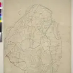
This plan covers part of East Anglia, with the town of Wisbech depicted at lower left. The Great Ouse estuary, depicted near top right, served as a way into the Port of Wisbech until it became so silted up that the river was diverted into the sea at Kings Lynn. Drains across fens and marshland are highlighted in blue. These date from the 17th century, when James I appointed Dutch engineer Cornelius Vermuyden to direct the drainage of the fens wetlands. Many local people opposed the scheme as the plan involved commonland on which they grazed cattle. As a result of Vermuyden's work, the Fens changed radically in appearance, from an area of flooded marshes to one of extensively farmed agricultural land.
The British Library1819
1819

