Dokument

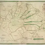
A Chart of the Fens between Lynn Regis, Denver Sluice and Wisbich
This is a plan of the Fenlands around Kings Lynn dating from around 1610. It is thought to be a close copy of a map of the same area by William Hayward dating from 1591, now lost. Fenlands are wet lands usually dominated by grasses and sedges, and often used for agricultural purposes. Here the fenland is divided into plots with the names of the land holder marked. Red roofed buildings provide a generalised view of Kings Lynn on the River Ouse. A scale bar records the scale in perches and furlongs and a decorative but unfinished cartouche dominates the top right corner.
The British LibraryHayward, William
1610

