3D

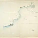
Map of the Orissa coast showing the Jagannath and Konarak temples
Watercolour map of the Orissa coast showing the Jagannatha and Konarak temples, by an anonymous artist working in the British school, part of the MacKenzie Collection, dated 1820. Orissa is situated on the eastern seaboard of India, south of Bengal. It is protected by the thickly forested mountains of the Eastern Ghats to the west and is open to the Bay of Bengal to the east. The coastal plains have the highest concentration of historical monuments while along the interior there is a tract of nearly-impenetrable hill country. The map shows two of the most famous temple sites, Puri and Konarak. Puri is one of the cardinal centres of pilgrimage for Hinduism and is the principal centre of the cult of Krishna in his form of Jagannatha, the Lord of the Universe. The Jagannatha temple was founded in the 12th Century by Anantavarman Chodaganga (r.1077-1147), ruler of the Eastern Ganga dynasty. The Rath Yatra (car festival) is the largest annual festival in Puri when the images of Jagannatha, his brother Balabhadra and sister Subhadra are placed in large chariots (raths) and are paraded about the town to symbolise the journey of Krishna from Gokul to Mathura. The great Sun Temple of Konarak stands on the Bay of Bengal, where thousands of pilgrims still come to bathe in the water during the spring festival to celebrate the birth of the Vedic sun god, Surya. The temple was constructed by Narashimhadev, king of the Eastern Ganga dynasty in the 13th century. Conceived as a gigantic chariot with twelve pairs of carved wheels, this temple is an architectural feat for the Orissan style.
The British Library1820
1820

