文件

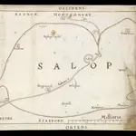
Map of Shropshire f. 75*
This is a manuscript map of Shropshire. It forms part of an atlat which belonged to Lord Burghley, Secretary of State to Elizabeth I, who used it to illustrate domestic matters. It shows only the principal towns, distinguishing between those with a castle and those without by means of a symbol of two connected towers with crenellations. The River Severn, marked Sabrina F, is charted. Lord Burghley has added a name adjacent to a place where the river is bridged. Lord Burghley was concerned with communication routes as revealed by his annotation. The draughtsman has indicated relief by hill symbols in two places. The map features a scale bar, but this is partly obscured by damage to the map.
The British Library1600

